Last
updated 22nd of January, 2013
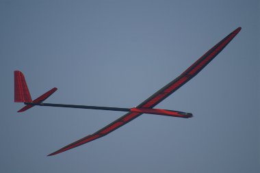
1025 traction transducer for F3J competitors in Ukrainia
Tips and tricks for F3B/F3J wire traction measurements in a new application note from Francisco Meschia
Francesco Meschia's outstanding article on F3J launch theory and appliction using our Max 1025 traction transducer
Measurement,
recording, telemetry, HUD for RC modelers
Get full control of your flight with the unique Xerivision HUD system:
With realtime display of barometric altitude, Air speed , GPS distance....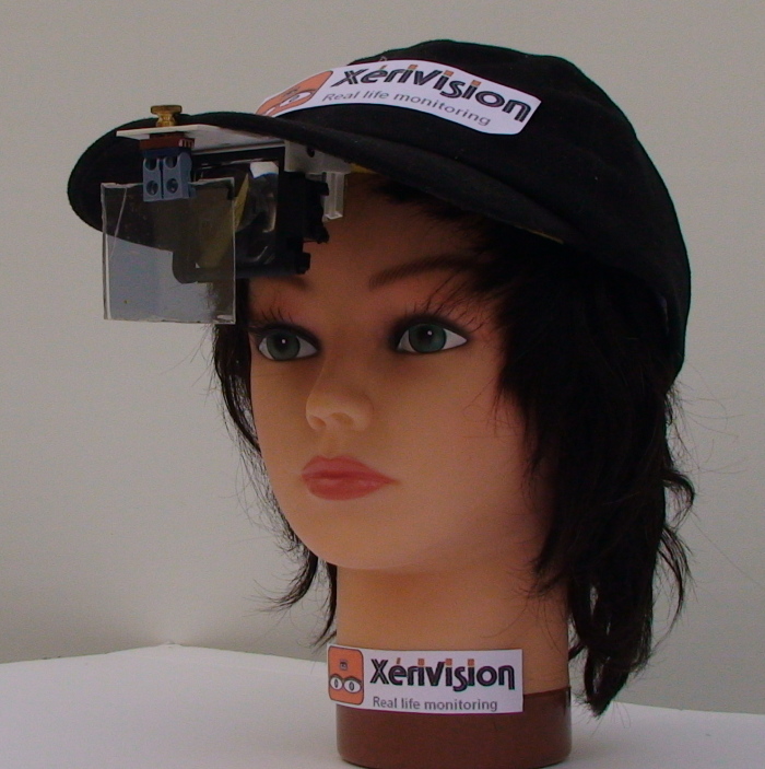
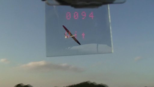
See our video on Youtube
NEW
Ukrainian
F3J competitors are now equiped wit Max 1025 traction transducer to
optimise their launch phases according to Francesco Meschia methods. No
doubts that, at the next F3J world championship, the level will be
increased and the competition will be harsh.
Francesco
Meschia complements his latest publication about F3B/F3J launch and
unveils his tips to be on the safe side for
efficient
measurements.
Learn from Francesco
Meschia's paper how
to improve by 10% the launch altitude of your F3J model thanks to
measurement of critical parameters.
 In the new issue of
the prestigeous Italian publication "Settimo Cielo"
Francesco provides a description of the process he has
developed to optimise the key parameters governing the launch phase of
an F3J model. Francesco drafted another expanded version of his study
for us. You can
find
it here.
In the new issue of
the prestigeous Italian publication "Settimo Cielo"
Francesco provides a description of the process he has
developed to optimise the key parameters governing the launch phase of
an F3J model. Francesco drafted another expanded version of his study
for us. You can
find
it here.These parameters were identified through a detailed theoretical analysis and then a rigourous experimental protocol he established. One of the prime key parameters continuously measured in flight during the winch launch phase is the pulling force of the wire on the model. This measurement is provided by a Xerivision Max 1025 traction transducer.
In addition to provide repetable and accurate measurements, the transducer has proven to be sturdy enough to resist to several tenths launches.
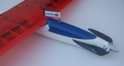
The lynx HUD has been connected to an Frsky 2.4GHz telemetry module
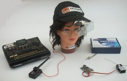 Frsky offers a line of 2.4GHz
emitter modules for Futaba andJR(TM) RC systems and the
corresponding receivers. The "Two ways modules" provide a downlink from
the onboard receiver back to the emitter. A Xerus airborne
data
management system has been interfaced with the receiver and the
measurements are forwarded to the ground. The pilot can thus
display in realtime
altitude and airspeed (and if a GPS module is added, the distance) of
his model
without loosing it out of sight.
More details
here.
Frsky offers a line of 2.4GHz
emitter modules for Futaba andJR(TM) RC systems and the
corresponding receivers. The "Two ways modules" provide a downlink from
the onboard receiver back to the emitter. A Xerus airborne
data
management system has been interfaced with the receiver and the
measurements are forwarded to the ground. The pilot can thus
display in realtime
altitude and airspeed (and if a GPS module is added, the distance) of
his model
without loosing it out of sight.
More details
here.The Frsky representative is Modelpascher shop.
 Genoma:
This is the latest
creation from Marc Pujol : 3.65 m of CFK
& Kevlar. It allies two opposites qualities: ultralight weight
(1.9kg including 1 Kw propulsion) and full air penetration. It
was designed using XFLR5, constructed by a highly
experienced mates and
performance sere measured using Xerision system. A complete dossier is
provided here. The distribution comes in two files: one Pdf for the
design
process and a
32 Mbyte heavy zip that provides all the details of
construction and fly. It includes tips and
tricks, measurement results as well. Upload here
Genoma:
This is the latest
creation from Marc Pujol : 3.65 m of CFK
& Kevlar. It allies two opposites qualities: ultralight weight
(1.9kg including 1 Kw propulsion) and full air penetration. It
was designed using XFLR5, constructed by a highly
experienced mates and
performance sere measured using Xerision system. A complete dossier is
provided here. The distribution comes in two files: one Pdf for the
design
process and a
32 Mbyte heavy zip that provides all the details of
construction and fly. It includes tips and
tricks, measurement results as well. Upload hereA new airflow angle transducer Mle 1401:
The aerodynamic performances of your competition
airplane
is constantly affected by the angle of attack, either yaw or pitch. We
have developed the new Max1401
transducer
in order to allow
the
model designers to investigate in this domain and the model's pilot
equiped with our HUD telemetry system to improve his skills and gain a
competitive advantage.
See the Marc Pujol's paper investigating the yaw behaviour of V tailed vs X tailed gliders, assessing his conclusion with Max 1401 angle transducer measurements.
Read our Application Note describing the concept of use of this transducer in connection with an HUD in our Application page
See the characteristics in our transducer products page
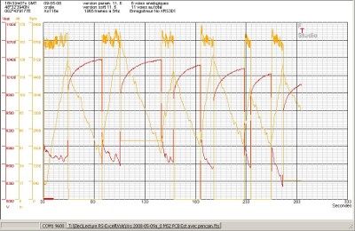
Record multiple transducers and with Flight Test Studio merge the data to access a subtle understanding of your flights:
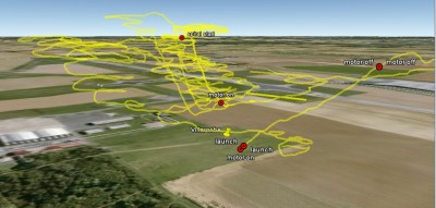
Save your airfield:
Your airfield is close to a built-up
area, your neighbours are clamouring in protest.
Don't worry, we can provide the solution.
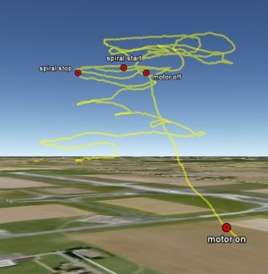
With the new 1.26 Xerus software release and our GPS receiver module, a pilot can continuously monitor how far his plane has travelled from
its starting point. He will be able to observe all "keep out" zones and avoid complaints from the neighbours about over-flying or aircraft noise .
Jet pilots, fans of models with big engines and club managers no longer need fear having their airfield closed by the authorities.
In addition, you will always know your plane's altitude and airspeed.
Don't worry, we can provide the solution.
With the new 1.26 Xerus software release and our GPS receiver module, a pilot can continuously monitor how far his plane has travelled from
its starting point. He will be able to observe all "keep out" zones and avoid complaints from the neighbours about over-flying or aircraft noise .
Jet pilots, fans of models with big engines and club managers no longer need fear having their airfield closed by the authorities.
In addition, you will always know your plane's altitude and airspeed.